Conservation Corner - September 2026
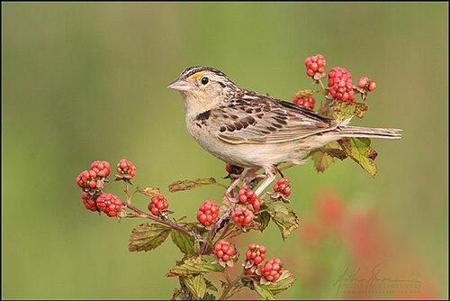
Grasshopper Sparrow photo by Matthew Studebaker.
Boulder Open Space and Mountain Parks (OSMP)
Multimodal Assessment Project: Ongoing Through February 2027
OSMP staff are working on a project to improve access to the City's Open Space trails. There have been two public engagement windows, in April and August, and ongoing opportunities to email the Boulder Open Space Board of Trustees (OSBT) and/or speak at their monthly meetings. Thank you to everyone who participated! Learn about the background for this project, submit questions, and sign up for updates here.
The Fairview High Mountain Bike team, Boulder Mountainbike Alliance, and others are asking the City for a direct trail connection through Open Space from Shanahan to Doudy Draw, which would mean adding bikes to existing trails and/or possibly constructing new trails. The existing trails in that area were designated bike-free during the 2011 West Trail Study Area Process, and the area has been designated as Colorado Tallgrass Prairie State Natural Area because of the high-quality habitat. Adding bikes to this area would go against determinations made in the 2011 West Trail Study Area Plan and increase impacts to the Tallgrass Prairie State Natural Area, which provides habitat to a number of grassland specialists - including the grasshopper sparrow, an interior grassland species and a Species of Special Concern in Boulder County.
Public Engagement Window 3 is planned for late October/early November. Stay tuned for BCAS alerts about that and other involvement opportunities
Save these Dates:
Wednesday Oct. 14 OSBT meeting- staff presents of draft package of solutions
Wednesday Dec.16 OSBT meeting - staff presents refined solutions package
Wednesday Feb. 10, 2027 OSBT meeting - staff presents final solutions
Recently Concluded Projects and Issues:
Boulder City Council Open Space Tax Issues
Thank you to everyone who wrote, called, or spoke in person about two measures that Boulder City Council considered for inclusion on the November ballot. One was not carried forward from Council study sessions after extensive public opposition, and the other was narrowly defeated in a formal Council vote.
The Public Realm Sales Tax potential ballot measure considered by Council this past spring would have including a measure to combine revenues from the dedicated Open Space Sales Tax Fund with funds for Transportation and Parks and Recreation into one “Public Realm” sales tax fund. This restructuring would have taken away the dedication of Open Space Sales Tax funds approved by voters and allow those funds to be diverted to other city services and amenities, such as roads. Council allowed the measure to move forward with staff work in March, then took it off the table in April/May after much public opposition.
The Downtown Development Authority (DDA) was a rather complicated proposal for a ballot measure to create a DDA. By state law, the measure could only be voted on by property owners, residents, and qualified business owners within the proposed DDA boundary, around 2000 people. The DDA would have used “Tax Increment Financing” which would have diverted open space and other dedicated sales tax revenues above a “base year” amount to the DDA for some period of time. The hope was that then there would be increased sales tax revenue from downtown that everyone could share in, but how and when it would be shared back were among the many details that would not be specified until/unless the DDA and some inter-governmental agreements were created. Council’s vote was a tie, which meant the proposal was defeated. BCAS, BCNA, PLAN-Boulder County, Indian Peaks Chapter of the Sierra Club, and Boulder Progressives all came out against it, and that opposition influenced the vote of at least one Council member.
As Boulder staff and City Council continue to address Boulder’s budget challenges, BCAS will need to stay vigilant to help protect dedicated open space sales taxes in future budget cycles.
Boulder Valley Comprehensive Plan Major Update
The update has been approved, and can be found here. Thanks to everyone who filled out online questionnaires, attended public open houses, or engaged in other ways.
Boulder County Parks and Open Space Alternating Trail Use Pilot Project
Boulder County Parks and Open Space (BCPOS) explored a temporary pilot for alternating usage on select trails to improve safety and enhance visitor experiences, and invited public input through open houses and an online questionnaire.
BCPOS staff then developed several alternatives for temporary changes on some trails at Heil Valley and Hall Ranch properties: 1) required directional travel for mountain bikes on some trails at Heil, 2) designating specific trails at Heil for hiker/equestrian-only and biker-only use on Thursdays, and 3) designating specific trails at Heil and Hall for hiker/equestrian-only and biker-only use on Wednesdays. Staff recommended Alternative 1.
On June 30, Boulder County Commissioners voted two to one against staff’s recommendation, leaving the status quo in place, and directed BCPOS staff to focus on working with trail users and the broader community to improve understanding of the rules and etiquette for trails shared by hikers, runners, cyclists, and equestrians.
Ongoing and upcoming projects:
North Foothills Bikeway
Boulder County is planning for a bikeway on the east side of Colorado Highway 36 between Boulder and Lyons. There have been public open houses and an online questionnaire. Thanks to all who have participated, and stay tuned for upcoming public involvement opportunities. Find out more and sign up for project updates here.
Highway 36 Wildlife Crossings
Boulder County Parks and Open Space is planning for wildlife crossings along Highway 36 south of Lyons, to address motorist safety and wildlife connectivity. This project overlaps with the North Foothills Bikeway and the two projects are being coordinated.
Find out more, view videos of presentations including one for BCAS in October 2024, and sign up for project updates here.
Boulder County Parks and Open Space District Level Planning
BCPOS has divided the County into six Districts, to plan on a larger scale instead of creating management plans for each individual property. The District they will start with is the Peak to Peak in the southwest part of Boulder County. For more info, you can view the video of the Boulder County Commissioners July 21 meeting here or the Parks and Open Space Advisory Committee meeting here. Stay tuned for updates and public involvement opportunities as the project gets underway.
Boulder to Erie Regional Trail
BCAS continues to follow this project as it progresses through the design phase, and we will alert our members of public comment opportunities, including the land use review process. The project website was recently updated, and you can send comments and questions to the project team at any time here.
The Boulder County Audubon Society leadership thanks the members of the BCAS Conservation Committee for their time and efforts in helping educate and advocate for Boulder County’s birds, wildlife, and their habitats. If you are interested in joining this effort, or any other BCAS committees, please contact us.