
Your Voice is Needed! Final Survey: East Boulder Creek Site Management Plan
By Bev Baker and Suzanne Bhatt, BCAS Conservation Committee
Boulder County Parks and Open Space (BCPOS) is creating a management plan for the East Boulder Creek (EBC) site. The site has experienced limited human access, and therefore species diversity is quite high on portions of the area, particularly Kenosha Wetlands and along Coal Creek. The EBC site consists of 1,377 acres and contains five miles of stream along Boulder and Coal Creeks (including one mile of restored floodplain), a dozen ponds, wetlands, reclaimed grasslands, grazing lands, and irrigated pasture lands. The location is along Boulder Creek from just west of CO Highway 287 at the site’s southwest corner, to County Line Road at the northeast corner.

The East Boulder Management Plant site is 1,377-acres composed of five individual open space properties that contain a dozen ponds and five miles of perennial stream along Boulder Creek and Coal Creek. For an interactive map, visit the BCPOS website.
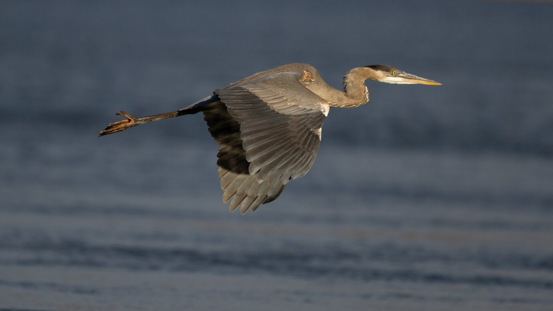
The EBC site includes Great Blue Heron heronry.
This special site needs your voice! The EBC site presents an opportunity to continue to protect and restore native prairie, riparian corridors, and other important habitats. Over 140 bird species and a variety of native mammals, amphibians, and other organisms have been observed using the site. To maintain this diversity, human access needs to be carefully planned. BCPOS is seeking public feedback and it is important for them to hear from people who value our local wildlife and habitats.
How Can You Help?
You can provide valuable feedback on the management plan by filling out the 3rd and final survey by midnight on October 29th. Learn more about the site, the management plan process, and timeline; read about the results of Survey 1 & 2; view photos and videos; and take the final survey by October 29th on the BCPOS EBC Management Plan webpage.
Content to Consider for Your Comments
BCAS is providing the following comments to BCPOS, the Parks and Open Space Advisory Committee (POSAC), and the County Commissioners. Please consider including the points most relevant for you. Your comments may be more effective if revised to use your own words.
These comments reference the Draft Management Plan (PDF) and Appendix A of the plan (PDF).
Also, consider commenting in person or by phone at upcoming meetings of POSAC and/or the Commissioners. You may also provide written comments to POSAC and the Boulder County Commissioners ahead of their meetings, through their websites.
The Boulder County Audubon Society (BCAS) Board of Directors is pleased to submit the following comments regarding the East Boulder Creek (EBC) Site Management Plan. BCAS’s mission is to be “a voice for birds and wildlife conservation through habitat protection, advocacy, and nature education.” As we have previously stated, we consider it of the utmost importance to prioritize protection, restoration, and enhancement of wildlife and habitats when determining how and where human access will be allowed at the EBC site.
BCAS appreciates staff’s hard work on the draft plan. We expect that the planned restoration activities will improve wildlife habitat on the site, and we support limiting access to East Boulder Creek to specific areas on the south side of the creek. We also support keeping the area closed from sunset to sunrise. Additionally, our members who attended field trips to the site found them to be informative and helpful. We would strongly support staff hosting site visits during future phases of the project.
We have the following concerns and questions about the draft plan:
1. Kenosha Pond Critical Wildlife Habitat and Coal Creek
We are concerned about the proposed trail along the north side of Kenosha Pond Critical Wildlife Habitat (CWH) and would like to see it eliminated, along with the proposed trail on the east side of Coal Creek. These areas provide some of the most valuable wildlife habitat on the site, and the trails are not needed in order to provide a future connection for Erie. We consider it important to avoid further fragmenting these areas. Eliminating these trails would contribute greatly to fulfilling Goal 2, Action: Protect Sensitive Wildlife Areas on p. 21 of the plan.
If the trail on the north side of the pond stays, how will people will be prevented from entering other areas around the pond?
The Northeast map on p. 23 of the plan shows the area west of Kenosha Pond closed to the public, along with the areas south and east of the pond. However, the Northeast map on p. 37 does not show the area west of the pond to be closed to the public.
We are concerned about the proximity of facilities around the stacked ponds to Kenosha Pond, including the parking lot, fishing access, play area, and shelter. We would like to see these facilities, particularly the play area and shelter, moved further west and away from Kenosha ponds and the heronry, and all of the facilities designed to draw people away from the CWH.
The mapped accessible trail travels right along the edge of the Kenosha Pond CWH. We believe this trail should be moved further west, as close to the road as possible, or better yet to the west side of the road if feasible. Also consider reducing parallel trails and therefore trail density in this area to help reduce wildlife impacts.
2. Raptors and heronry
How will raptor nests be protected, particularly where proposed trails are within buffer zones, such as the nest along Coal Creek at the southeast corner of the northeast map on p. 37? Planning trails close to raptor nests where months-long seasonal closures may be needed during nesting season seems like a setup for management headaches and visitor frustration.
What is the plan for the osprey nest close to the entrance that leads to the stacked ponds, parking lot and other proposed facilities?
Appendix A on p.8 states that a network of trails could irreversibly diminish long-term use of the area by bald eagles. How has this concern been taken into account in the plan?
Since heronries move periodically, will measures be taken if the heronry moves to a location that needs additional protection?
3. Rangers, wildlife monitoring, creek access, invasives prevention, wildlife impacts
The draft plan places much emphasis on ranger presence for education, resource protection, and enforcement. We support this concept; however we have concerns about how realistic it is given funding and staffing constraints. With the proximity of Erie and the proposed trail connections to town trails, will Erie help fund ranger presence and/or or provide some staffing?
Monitor wildlife, p. 21 of plan - if negative effects to wildlife or habitat are found based on monitoring, will actions be taken to reverse or mitigate effects?
Creek access - we appreciate that few areas are designated for creek access, and would like to see this access limited to the smallest areas possible so that impacts do not spread out and increase over time, and to help limit risk of invasive organisms spread.
We consider it very important to add invasives prevention measures, such as boot cleaning stations (including regular maintenance), thorough inspection of all equipment to be used for construction or maintenance, and including prevention measures for aquatic invasives, such as New Zealand mudsnails, which already occur in several locations upstream of the East Boulder Creek site. This content could be added as a Priority under Goal 2, as it is relevant to all of the Priorities under this goal.
Wildlife impacts: Draft plan p. 3 contains the statement “The Department will provide public access and supporting infrastructure in locations that do not negatively impact wildlife.” P. 7 Goal 5 contains the statement “Recreational experiences will be placed where they do not have negative environmental impacts.” Human access and construction will have impacts to wildlife and the environment. It would be more accurate to say that impacts will be minimized.
Appendix A p. 8, last sentence of the paragraph about Environmental Conservation Areas (ECAs) indicates that wildlife values of the ECAs, Critical Wildlife Habitat, and riparian corridors would be diminished if human impacts are not maintained at low intensity. With proximity of the site to Erie and increasing Open Space visitation, it does not seem realistic that human use at the site will be low intensity. However, human impacts to wildlife and the most important habitats can be reduced by eliminating the proposed trails along the north side of Kenosha Pond and the east side of Coal Creek, and other proactive measures as discussed above.

Belted Kingfisher.